|
08-2028
|
Developing an operational Sargassum monitoring and forec
Developing an operational Sargassum monitoring and forec
|
|
05-2028
|
Geostationary Littoral Imaging and Monitoring Radiometer (GLIMR)
Geostationary Littoral Imaging and Monitoring Radiometer (GLIMR)
|
|
06-2026
|
Maritime Transportation, Satellite Earth Observations, a
Maritime Transportation, Satellite Earth Observations, a
|
|
05-2026
|
Monitoring and forecasting pelagic Sargassum in the Sout
Monitoring and forecasting pelagic Sargassum in the Sout
|
|
08-2025
|
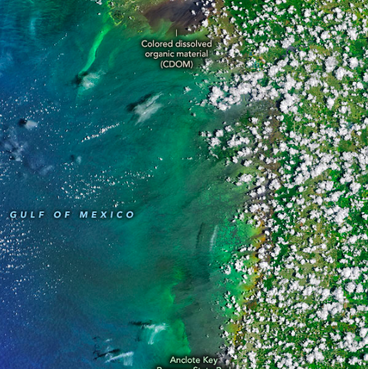
Linking biogeochemical and optical water quality in coas
Linking biogeochemical and optical water quality in coas
|
|
06-2025
|
Determining long term trends in Florida Keys water quali
Determining long term trends in Florida Keys water quali
|
|
06-2025
|
New interdisciplinary approaches to red tide tracking an
New interdisciplinary approaches to red tide tracking an
|
|
06-2024
|
The Caribbean Coastal Ocean Observing System: A responsive stakeholder-driven observing system addressing regional and national needs in the US Caribbean
The Caribbean Coastal Ocean Observing System: A responsive stakeholder-driven observing system addressing regional and national needs in the US Caribbean
|
|
05-2024
|
Remote sensing of marine debris: potentials and limitati
Remote sensing of marine debris: potentials and limitati
|
|
03-2024
|
On the capacity of Capella Space X-band SAR in detecting
On the capacity of Capella Space X-band SAR in detecting
|
|
12-2023
|
Deciphering Sargassum Physics, Biology, and Physiology T
Deciphering Sargassum Physics, Biology, and Physiology T
|
|
04-2023
|
Long-term assessment of algal blooms and water quality i
Long-term assessment of algal blooms and water quality i
|
|
09-2022
|
Spectral Matching Inversion Algorithms for PACE Applicat
Spectral Matching Inversion Algorithms for PACE Applicat
|
|
08-2022
|
Sub-Mesoscale Eddies Derived From Novel Ocean Color Imagery and ICES at Missions in Support of the SWOT Mission
Sub-Mesoscale Eddies Derived From Novel Ocean Color Imagery and ICES at Missions in Support of the SWOT Mission
|
|
06-2022
|
The Caribbean Coastal Ocean Observing System: A responsi
The Caribbean Coastal Ocean Observing System: A responsi
|
|
06-2022
|
Analysis of Archived Piney Point Samples
Analysis of Archived Piney Point Samples
|
|
06-2022
|
Satellite Remote Sensing for Physical and Biophysical Mo
Satellite Remote Sensing for Physical and Biophysical Mo
|
|
05-2022
|
CARICOOS: Enhancing Coastal Intelligence for the
CARICOOS: Enhancing Coastal Intelligence for the
|
|
03-2022
|
Precipitation, Water Management and Algae Blooms in South Florida Estuaries
Precipitation, Water Management and Algae Blooms in South Florida Estuaries
|
|
02-2022
|
Thermal Stress in South Florida Estuaries: A Multi-Sensor Assessment
Thermal Stress in South Florida Estuaries: A Multi-Sensor Assessment
|
|
05-2021
|
CARICOOS: Enhancing Coastal Intelligence for the US Cari
CARICOOS: Enhancing Coastal Intelligence for the US Cari
|
|
09-2020
|
Forecasts of Pelagic Sargassum Blooms and Transports in
Forecasts of Pelagic Sargassum Blooms and Transports in
|
|
06-2020
|
Satellite remote sensing support of red tide monitoring
Satellite remote sensing support of red tide monitoring
|
|
06-2020
|
Remote Sensing Support of Red Tide Studies
Remote Sensing Support of Red Tide Studies
|
|
05-2020
|
Calibration/Validation Support for NPP VIIRS Data Produc
Calibration/Validation Support for NPP VIIRS Data Produc
|
|
05-2020
|
Linking Habitat to Recruitment: Evaluating the Importanc
Linking Habitat to Recruitment: Evaluating the Importanc
|
|
03-2020
|
Retrospective Analysis of Karenia Brevis Blooms on the West Florida Shelf
Retrospective Analysis of Karenia Brevis Blooms on the West Florida Shelf
|
|
12-2019
|
Distribution and Abundance of Pelagic Sargassum and thei
Distribution and Abundance of Pelagic Sargassum and thei
|
|
12-2019
|
Response of Carbon Cycling in two North American Subtrop
Response of Carbon Cycling in two North American Subtrop
|
|
12-2019
|
Southeastern Gulf of Mexico Processes Affecting Basin-Wi
Southeastern Gulf of Mexico Processes Affecting Basin-Wi
|
|
10-2019
|
ACAM and GCAS Data Processing to Support GEO-CAPE
ACAM and GCAS Data Processing to Support GEO-CAPE
|
|
09-2019
|
North Atlantic Aerosols and Marine Ecosystems Study (NAA
North Atlantic Aerosols and Marine Ecosystems Study (NAA
|
|
06-2019
|
Synergistic Multi-sensor Calibration for Global and Coas
Synergistic Multi-sensor Calibration for Global and Coas
|
|
05-2019
|
Calibration/Validation Support for NPP VIIRS Data Product Continuity
Calibration/Validation Support for NPP VIIRS Data Product Continuity
|
|
12-2018
|
Influence of River Induced Fronts on Hydrocarbon Transport
Influence of River Induced Fronts on Hydrocarbon Transport
|
|
08-2018
|
PCMHAB: Seasonal Forecasting of Karenia Brevis Blooms in the Eastern Gulf of Mexico
PCMHAB: Seasonal Forecasting of Karenia Brevis Blooms in the Eastern Gulf of Mexico
|
|
08-2018
|
The Development of a Water Clarity Index for the Great Lakes as a Climate Indicator (Subcontract with Kent State)
The Development of a Water Clarity Index for the Great Lakes as a Climate Indicator (Subcontract with Kent State)
|
|
12-2017
|
Physical Oceanographic Sensing and Validation
Physical Oceanographic Sensing and Validation
|
|
12-2017
|
The Center for the Integrated Modeling and Analysis of G
The Center for the Integrated Modeling and Analysis of G
|
|
09-2017
|
Calibration/Validation Support for NPP VIRS Data Product Continuity
Calibration/Validation Support for NPP VIRS Data Product Continuity
|
|
09-2017
|
Refine and Improve Suomi NPP Chlorophyll A and Other Oce
Refine and Improve Suomi NPP Chlorophyll A and Other Oce
|
|
08-2017
|
Continued Operation and Maintenance of the CenGoos Buoy
Continued Operation and Maintenance of the CenGoos Buoy
|
|
08-2017
|
Ocean Surface Oil Detection and Quantification with Hype
Ocean Surface Oil Detection and Quantification with Hype
|
|
03-2017
|
Predicting Sargassum Blooms in the Caribbean and Lesser
Predicting Sargassum Blooms in the Caribbean and Lesser
|
|
12-2016
|
Establish a Multi-Sensor Climate Data Record of Ocean Chlorophyll-A Concentrations Using a Novel Algorithm Concept
Establish a Multi-Sensor Climate Data Record of Ocean Chlorophyll-A Concentrations Using a Novel Algorithm Concept
|
|
12-2016
|
Maximize MODIS Potentials for Near Real-time Ocean Applications through Developing and Refining Novel Algorithms and Products
Maximize MODIS Potentials for Near Real-time Ocean Applications through Developing and Refining Novel Algorithms and Products
|
|
12-2016
|
The Hyperspectral CO2 and Methane MONITORING (HyCOMM) Campaign
The Hyperspectral CO2 and Methane MONITORING (HyCOMM) Campaign
|
|
11-2016
|
Satellite Water Quality to Support Seagrass Recovery
Satellite Water Quality to Support Seagrass Recovery
|
|
08-2016
|
Characterization and Correction of Land Adjacency Effects on Ocean Color Imagery Over Near-Shore and Inland Waters
Characterization and Correction of Land Adjacency Effects on Ocean Color Imagery Over Near-Shore and Inland Waters
|
|
11-2015
|
High-Resolution Cloud Statistics of U.S. Coastal Waters
High-Resolution Cloud Statistics of U.S. Coastal Waters
|
|
08-2015
|
Remote Sensing Assessment of Surface Oil Transport and Fate During Spills in the Gulf of Mexico
Remote Sensing Assessment of Surface Oil Transport and Fate During Spills in the Gulf of Mexico
|
|
07-2015
|
Analysis of and Interpretation of DISCOVER-AQ Data for GEO-CAPE Mission Planning
Analysis of and Interpretation of DISCOVER-AQ Data for GEO-CAPE Mission Planning
|
|
05-2015
|
Calibration/Validation Support for NPP VIIRS Data Product Continuity
Calibration/Validation Support for NPP VIIRS Data Product Continuity
|
|
02-2015
|
Detect and Quantify Methane and Carbon Dioxide Emissions for Marine and Terrestrial Environments Using Airborne SWIR and TIR Remote Sensing: A Collaborative NASA/ESA Calibratin and Validation Project
Detect and Quantify Methane and Carbon Dioxide Emissions for Marine and Terrestrial Environments Using Airborne SWIR and TIR Remote Sensing: A Collaborative NASA/ESA Calibratin and Validation Project
|
|
01-2015
|
Development of a Water Clarity Index for the Southeastern U.S. as a Climate Indicator
Development of a Water Clarity Index for the Southeastern U.S. as a Climate Indicator
|
|
12-2014
|
A Multi-Sensor Assessment of the Deepwater Horizon Oil Spill: Surface Oil Volume and Impact on Marine Algae
A Multi-Sensor Assessment of the Deepwater Horizon Oil Spill: Surface Oil Volume and Impact on Marine Algae
|
|
09-2014
|
Sediment on Reef's and Adjacent Coastal Areas: Information tools for Managers in American Samoa, South Florida, CNMI
Sediment on Reef's and Adjacent Coastal Areas: Information tools for Managers in American Samoa, South Florida, CNMI
|
|
09-2013
|
High Resolution Assessment of Carbon Dynamics in Seagrass and Coral Reef Biomes
High Resolution Assessment of Carbon Dynamics in Seagrass and Coral Reef Biomes
|
|
08-2013
|
Physics-based Ocean-color Algorithms for Water-quality Products of Coastal and Inland Waters
Physics-based Ocean-color Algorithms for Water-quality Products of Coastal and Inland Waters
|
|
12-2012
|
West Florida Shelf Glider Deployments and Data Dissemination for GCOOS-RA
West Florida Shelf Glider Deployments and Data Dissemination for GCOOS-RA
|
|
09-2012
|
Mapping and Forecasting of Pelagic Sargassum Drift Habitat in the Gulf of Mexico and South Atlantic Bight for Decision Support
Mapping and Forecasting of Pelagic Sargassum Drift Habitat in the Gulf of Mexico and South Atlantic Bight for Decision Support
|
|
06-2012
|
Bio-optical and Taxonomy Measurements in the Upper Chesapeake Bay to Assist GEO-CAPE Mission
Bio-optical and Taxonomy Measurements in the Upper Chesapeake Bay to Assist GEO-CAPE Mission
|
|
09-2011
|
ECOHAB:Remote Detection of Harmful Algal Blooms in the Eastern Gulf of Mexico
ECOHAB:Remote Detection of Harmful Algal Blooms in the Eastern Gulf of Mexico
|
|
08-2011
|
Enhancing Estuarine Water Quality Management Through Integrating Earth Science Research Results: A Targeted project for Tampa Bay, Florida
Enhancing Estuarine Water Quality Management Through Integrating Earth Science Research Results: A Targeted project for Tampa Bay, Florida
|
|
07-2011
|
Novel Ocean Color Products for Eddy Tracking and W
Novel Ocean Color Products for Eddy Tracking and W
|
|
07-2011
|
Implementation of Regional Integrated Ocean Observ
Implementation of Regional Integrated Ocean Observ
|
|
07-2011
|
Remote Sensing Decision Support for Water Quality Assessment and Seagrass Protection and Management in Florida's Big Bend Region
Remote Sensing Decision Support for Water Quality Assessment and Seagrass Protection and Management in Florida's Big Bend Region
|
|
06-2011
|
Harmful Algal Bloom (HAB) Monitoring and Event Res
Harmful Algal Bloom (HAB) Monitoring and Event Res
|
|
06-2011
|
Mapping Water-Quality Parameters using Satellite Imagery in the Florida Keys
Mapping Water-Quality Parameters using Satellite Imagery in the Florida Keys
|
|
10-2010
|
Evaluation of Marine Productivity Study for the OCS Planning Areas
Evaluation of Marine Productivity Study for the OCS Planning Areas
|
|
09-2010
|
Nutrient Linkages Between South Florida Rivers and Coastal Habitats: Integrating Water Quality Sampling with Satellite Remote Sensing to Enhance Management
Nutrient Linkages Between South Florida Rivers and Coastal Habitats: Integrating Water Quality Sampling with Satellite Remote Sensing to Enhance Management
|
|
07-2009
|
Implementation of Regional Integrated Ocean Observing Systems Support of RCOOS Development in SECOORA: Data Management - USF Year 1
Implementation of Regional Integrated Ocean Observing Systems Support of RCOOS Development in SECOORA: Data Management - USF Year 1
|
|
09-2008
|
SECOORA RCOOS Remote Sensing Component
SECOORA RCOOS Remote Sensing Component
|
|
07-2008
|
A Binational Gulf of Mexico HAB Risk Assessment and Communications Partnership: Red Antares
A Binational Gulf of Mexico HAB Risk Assessment and Communications Partnership: Red Antares
|
|
04-2008
|
An Assessment of Global Organic Carbon Flux Along Continental Margins
An Assessment of Global Organic Carbon Flux Along Continental Margins
|
|
12-2007
|
The Influence of the Amazon and Orionoco River Plumes on the Tropical Atlantic Climate
The Influence of the Amazon and Orionoco River Plumes on the Tropical Atlantic Climate
|
|
04-2007
|
Remote Sensing Support of the TAMRF Project: "A Cooperative Research Study on Sperm Whales and their Response to Seismic Exploration in the Gulf of Mexico." MMS Cooperative Agreement 1435-01-02_CA-85186.
Remote Sensing Support of the TAMRF Project: "A Cooperative Research Study on Sperm Whales and their Response to Seismic Exploration in the Gulf of Mexico." MMS Cooperative Agreement 1435-01-02_CA-85186.
|
|
03-2007
|
Atmospheric Correction of Satellite Ocean Color Imagery in Turbid Coastal Waters: A Self-tuning Approach
Atmospheric Correction of Satellite Ocean Color Imagery in Turbid Coastal Waters: A Self-tuning Approach
|
|
03-2007
|
NASA Marshall Space Flight Center/USF Cooperative Agreement Year 1/Task 1
NASA Marshall Space Flight Center/USF Cooperative Agreement Year 1/Task 1
|
|
09-2006
|
EATLE-EYE: Ecological Assessment of Generalized Littoral Environments - an Integrated EOS DB/Real-Time MODIS Science Applications Project
EATLE-EYE: Ecological Assessment of Generalized Littoral Environments - an Integrated EOS DB/Real-Time MODIS Science Applications Project
|
|
08-2006
|
SEA-COOS Remote Sensing Component
SEA-COOS Remote Sensing Component
|
|
07-2006
|
Rapid Prototyping of NASA Data within NOAA Coral Reef Decision Support Tools
Rapid Prototyping of NASA Data within NOAA Coral Reef Decision Support Tools
|
|
02-2006
|
Long-Term Measurement of Physical, Chemical and Bilogical Water Column Properties in the South Florida Coastal Ecosytem
Long-Term Measurement of Physical, Chemical and Bilogical Water Column Properties in the South Florida Coastal Ecosytem
|
|
09-2005
|
The Oceanography of Intermittent Harmful Algal Blooms (HAB) Off the Caloosahatchee River, FL Satellite and Other Sensing
The Oceanography of Intermittent Harmful Algal Blooms (HAB) Off the Caloosahatchee River, FL Satellite and Other Sensing
|
|
08-2004
|
MOVEMENT PATTERNS AND DIVING BEHAVIOR OF ATLANTIC SPOTTED DOLPHINS (sTENELLA fRONTALIS): A REMOTE SENSING iNTERPRENTATION
MOVEMENT PATTERNS AND DIVING BEHAVIOR OF ATLANTIC SPOTTED DOLPHINS (sTENELLA fRONTALIS): A REMOTE SENSING iNTERPRENTATION
|
|
07-2004
|
COASTAL REMOTE SENSING WITH THE STATION HYPERSPECTRAL OCEAN RESEARCH EXPERIMENT (SHORE)
COASTAL REMOTE SENSING WITH THE STATION HYPERSPECTRAL OCEAN RESEARCH EXPERIMENT (SHORE)
|
|
06-2004
|
Monitoring of the Piney Point Discharge on the West Florida Shelf with Satellite Remote Sensing
Monitoring of the Piney Point Discharge on the West Florida Shelf with Satellite Remote Sensing
|
|
03-2004
|
A Feasibility Study of the High Resolution MODIS Bands in Estuarine Monitoring
A Feasibility Study of the High Resolution MODIS Bands in Estuarine Monitoring
|
|
10-2002
|
Development of a Simple Remote-Sensing Instrument for Aquatic Applications
Development of a Simple Remote-Sensing Instrument for Aquatic Applications
|