
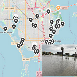
A team led by USF’s Barnali Dixon developed the Community Resiliency Information System (CRIS) HAZARD app, which combines user-submitted, geolocated photos and AI to track flood conditions in real time and help Pinellas County residents identify dangers. Users can estimate water depth using body reference points such as ankle or knee height.
The system was upgraded recently with the addition of 23 static cameras that capture images every 15 minutes from flood-prone areas and are uploaded directly to the system. When residents upload photos, the system automatically identifies the nearest camera and uses computer vision and a machine learning model to analyze water depth. Those data are then compared with the camera images to increase accuracy.
View Related Expert Profiles: Go to Source